Search
You Searched For
Search Results
- Published / Created:
- 1741
- Call Number:
- 765 1741
- Container / Volume:
- BRBL_00463
- Image Count:
- 1
- Resource Type:
- Maps, Atlases & Globes
- Subject (Geographic):
- Rhode Island--Maps--Early works to 1800
- Found in:
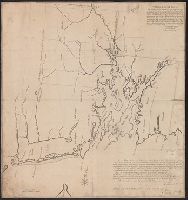
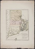
- Beinecke Rare Book and Manuscript Library > An exact Plan of the Sea Coast of the Continent, fron Paucatuck River, Eastwards, to Point Judith, and from thence, Nortwards, to the Town of Providence, ... to Slocums Harbour ... Jas. Helme, Wm. Chandler, Surveyrs. By order of his Matys.
- Published / Created:
- 1796?]
- Call Number:
- 765 1796
- Container / Volume:
- BRBL_00463
- Image Count:
- 1
- Resource Type:
- Maps, Atlases & Globes
- Subject (Geographic):
- Rhode Island--Maps--Early works to 1800
- Found in:
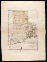
- Beinecke Rare Book and Manuscript Library > The state of Rhode Island; compiled from the surveys and observations of Caleb Harris, by Harding Harris.
- Published / Created:
- [1668]
- Call Number:
- 765 P29 1668
- Container / Volume:
- BRBL_00711
- Image Count:
- 2
- Resource Type:
- Maps, Atlases & Globes
- Subject (Geographic):
- Rhode Island--Maps, Manuscript--Early
- Found in:
- Beinecke Rare Book and Manuscript Library > [Manuscript map of Pawtuxet. Plot of Land near the Antler Green Tavern on Pawtuxet Road].
- Creator:
- Sotzmann, D. F
- Published / Created:
- 1797
- Call Number:
- 765 1797
- Container / Volume:
- BRBL_00729
- Image Count:
- 1
- Resource Type:
- Maps, Atlases & Globes
- Subject (Geographic):
- Rhode Island--Maps--Early works to 1800
- Found in:
- Beinecke Rare Book and Manuscript Library > Rhode Island / entworfen von D.F. Sotzmann ; gestochen von H. Kliewer.
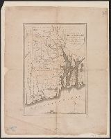
- Creator:
- Sotzmann, D. F
- Published / Created:
- 1797
- Call Number:
- 765 1797
- Container / Volume:
- BRBL_00463
- Image Count:
- 1
- Resource Type:
- Maps, Atlases & Globes
- Subject (Geographic):
- Rhode Island--Maps--Early works to 1800
- Found in:
- Beinecke Rare Book and Manuscript Library > Rhode Island / entworfen von D.F. Sotzmann ; gestochen von H. Kliewer.
- Creator:
- Bohn, Carl Ernst
Ebeling, Christophe Daniel, 1741-1817. Erdbeschreibung und Geschichte von Amerika
Kliewer, Heinrich, engraver
Sotzmann, D. F
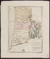
- Published / Created:
- 1797
- Call Number:
- 1977 Folio 177
- Image Count:
- 2
- Resource Type:
- Maps, Atlases & Globes
- Subject (Geographic):
- Rhode Island--Maps--Early works to 1800
- Found in:
- Beinecke Rare Book and Manuscript Library > Rhode Island / entworfen von D.F. Sotzmann ; gestochen von H. Kliewer.
- Published / Created:
- 1776]
- Call Number:
- 766 1776
- Container / Volume:
- BRBL_00690
- Image Count:
- 1
- Resource Type:
- Maps, Atlases & Globes
- Subject (Geographic):
- Rhode Island--Maps--Early works to 1800
- Found in:
- Beinecke Rare Book and Manuscript Library > A map of Connecticut and Rhode Island with Long Island Sound, &c.
- Published / Created:
- 1774 November 29
- Call Number:
- 1975 Folio 51
- Collection Title:
- The American atlas; or, A geographical description of the whole continent of America; wherein are
- Image Count:
- 1
- Resource Type:
- Maps, Atlases & Globes
- Subject (Geographic):
- Rhode Island --Maps --Early works to
- Found in:
- Beinecke Rare Book and Manuscript Library > A map of the most inhabited part of New England, containing the provinces of Massachusets Bay and New Hampshire, with the colonies of Conecticut and Rhode Island, divided into counties and townships: the whole composed from actual surveys and its situatio
- Call Number:
- 1973 Folio 116
- Collection Title:
- The English pilot: describing the West-India navigation, from Hudson's-Bay to the river Amazones
- Image Count:
- 1
- Subject (Geographic):
- Rhode Island --Maps --Early works to
- Found in:
- Beinecke Rare Book and Manuscript Library > A correct map of the coast of New England