Search
You Searched For
Search Results
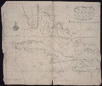
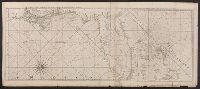
- Creator:
- Thornton, John, 1641-1708
- Call Number:
- 1973 Folio 76
- Collection Title:
- The English pilot: describing the sea-coasts, capes, head-lands, rivers, bays, roads, havens
- Image Count:
- 1
- Subject (Geographic):
- Bahamas --Maps --Early works to 1800
- Found in:
- Beinecke Rare Book and Manuscript Library > A new chart of the Bahama Islands and the Windward Passage
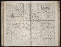
- Call Number:
- 1978 Folio 10
- Collection Title:
- The English pilot: describing the West-India navigation, from Hudson's-Bay to the river Amazones
- Image Count:
- 1
- Subject (Geographic):
- Bahamas --Maps --Early works to 1800
- Found in:
- Beinecke Rare Book and Manuscript Library > A new chart of the Bahama Islands and the Windward passage
- Creator:
- Jefferys, Thomas, -1771
- Published / Created:
- 20 Feby., 1775.
- Call Number:
- 792cea 1775C
- Container / Volume:
- BRBL_00519
- Image Count:
- 1
- Resource Type:
- Maps, Atlases & Globes
- Subject (Geographic):
- Bahamas--Maps--Early works to 1800
- Found in:
- Beinecke Rare Book and Manuscript Library > The island of Cuba with part of the Bahama banks & the Martyrs / by Thos. Jefferys.
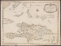
- Creator:
- L'Isle, Guillaume de, 1675-1726
- Published / Created:
- [1730]
- Call Number:
- 853 1722
- Container / Volume:
- BRBL_00694
- Image Count:
- 1
- Resource Type:
- Maps, Atlases & Globes
- Subject (Geographic):
- Bahamas--Maps--Early works to 1800
- Found in:
- Beinecke Rare Book and Manuscript Library > Carte de l'Isle de Saint Domingue / dressée en 1722 pour l'usage du Roy sur les memoires de Mr. Frezier, ingenieur de S.M. et autres, assujettis aux observations astronomiques, par G. De l'Isle ...
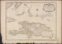
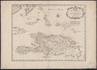
- Creator:
- L'Isle, Guillaume de, 1675-1726
- Published / Created:
- 1725
- Call Number:
- 853 1725A
- Container / Volume:
- BRBL_00694
- Image Count:
- 1
- Resource Type:
- Maps, Atlases & Globes
- Subject (Geographic):
- Bahamas--Maps--Early works to 1800
- Found in:
- Beinecke Rare Book and Manuscript Library > Carte de l'isle de Saint Domingue / dressée en 1722 pour l'usage du Roy sur les memoires de Mr. Frezier, ingenieur de S.M. et autres, assujettis aux observations astronomiques, par G. De l'Isle ...
- Creator:
- L'Isle, Guillaume de, 1675-1726
- Published / Created:
- 1725
- Call Number:
- 853 1725
- Container / Volume:
- BRBL_00640
- Image Count:
- 1
- Resource Type:
- Maps, Atlases & Globes
- Subject (Geographic):
- Bahamas--Maps--Early works to 1800
- Found in:
- Beinecke Rare Book and Manuscript Library > Carte de l'isle de Saint Domingue / dressée en 1722 pour l'usage du Roy sur les memoires de Mr. Frezier, ingenieur de S.M. et autres, assujettis aux observations astronomiques, par G. De l'Isle ...
- Creator:
- Jefferys, Thomas, -1771, cartographer
- Published / Created:
- 20 Feby. 1775.
- Call Number:
- 792cea 1775B
- Container / Volume:
- BRBL_00730
- Image Count:
- 1
- Resource Type:
- Maps, Atlases & Globes
- Subject (Geographic):
- Bahamas--Maps--Early works to 1800
- Found in:
- Beinecke Rare Book and Manuscript Library > The coast of West Florida and Louisiana : the Peninsula and Gulf of Florida or Channel of Bahama with the Bahama Islands / by Thos. Jefferys ...
- Creator:
- Jefferys, Thomas, -1771, cartographer
- Published / Created:
- 20 Feby. 1775.
- Call Number:
- 792cea 1775A
- Container / Volume:
- BRBL_00691
- Image Count:
- 1
- Resource Type:
- Maps, Atlases & Globes
- Subject (Geographic):
- Bahamas--Maps--Early works to 1800
- Found in:
- Beinecke Rare Book and Manuscript Library > The coast of West Florida and Louisiana : the Peninsula and Gulf of Florida or Channel of Bahama with the Bahama Islands / by Thos. Jefferys ...
- Creator:
- Jefferys, Thomas, d. 1771
- Published / Created:
- 20 Feby. 1775.
- Call Number:
- 792cea 1775
- Container / Volume:
- BRBL_00519
- Image Count:
- 1
- Resource Type:
- Maps, Atlases & Globes
- Subject (Geographic):
- Bahamas--Maps--Early works to 1800
- Found in:
- Beinecke Rare Book and Manuscript Library > The coast of West Florida and Louisiana [cartographic material] : the Peninsula and Gulf of Florida or Channel of Bahama with the Bahama Islands / by Thos. Jefferys ...