Search
You Searched For
Search Results
- Creator:
- Vancouver, George, 1757-1798
- Published / Created:
- 1798
- Call Number:
- 845 1798F
- Container / Volume:
- BRBL_00619
- Image Count:
- 1
- Resource Type:
- Maps, Atlases & Globes
- Subject (Geographic):
- Alaska--Map--Early works to 1800
- Subject (Topic):
- Coasts--Alaska--Maps--Early works to
- Found in:
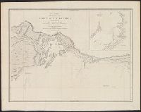
- Beinecke Rare Book and Manuscript Library > A chart shewing part of the coast of N.W. America, with the tracks of His Majesty's sloop Discovery and armed tender Chatham / commanded by George Vancouver, esqr. and prepared under his immediate inspection by Lieut. Joseph Baker, in which the continenta
- Creator:
- Vancouver, George, 1757-1798
- Published / Created:
- 1798
- Call Number:
- 845 1798D
- Container / Volume:
- BRBL_00619
- Image Count:
- 1
- Resource Type:
- Maps, Atlases & Globes
- Subject (Geographic):
- Alaska--Maps--Early works to 1800
- Subject (Topic):
- Coasts--Alaska--Maps--Early works to
- Found in:
- Beinecke Rare Book and Manuscript Library > A chart shewing part of the coast of N.W. America, with the tracks of His Majesty's sloop Discovery and armed tender Chatham / commanded by George Vancouver, esqr. and prepared under his immediate inspection by Lieut. Joseph Baker, in which the continenta
- Creator:
- Vancouver, George, 1757-1798
- Published / Created:
- 1798
- Call Number:
- 845 1798E
- Container / Volume:
- BRBL_00619
- Image Count:
- 1
- Resource Type:
- Maps, Atlases & Globes
- Subject (Geographic):
- Alaska--Maps--Early works to 1800
- Subject (Topic):
- Coasts--Alaska--Maps--Early works to
- Found in:
- Beinecke Rare Book and Manuscript Library > A chart shewing part of the coast of N.W. America, with the tracks of His Majesty's sloop Discovery and armed tender Chatham / commanded by George Vancouver, esqu. and prepared under his immediate inspection by Lieut. Joseph Baker, in which the continenta
- Creator:
- Vancouver, George, 1757-1798
- Published / Created:
- 1798
- Call Number:
- 845 1798B
- Container / Volume:
- BRBL_00619
- Image Count:
- 1
- Resource Type:
- Maps, Atlases & Globes
- Subject (Geographic):
- Alaska--Maps--Early works to 1800
- Subject (Topic):
- Coasts--Alaska--Maps--Early works to
- Found in:
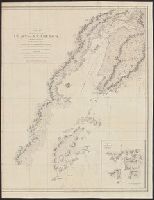
- Beinecke Rare Book and Manuscript Library > A chart shewing part of the coast of N.W. America, with the tracks of His Majesty's sloop Discovery and armed tender Chatham / commanded by George Vancouver, esqr. and prepared from the foregoing surveys under his immediate inspection by Lieut. Edwd. Robe
- Published / Created:
- 1795?]
- Call Number:
- 848cea 1795
- Container / Volume:
- BRBL_00635
- Image Count:
- 1
- Resource Type:
- Maps, Atlases & Globes
- Subject (Geographic):
- Alaska--Maps--Early works to 1800
- Found in:
- Beinecke Rare Book and Manuscript Library > Cartie de la partie de la côte nord-ouest de l'Amérique ... par le capitaine George Vancouver ... Redigée par le lieutenant Edward Roberts ...
- Published / Created:
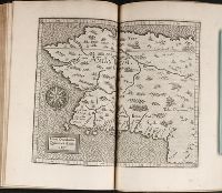
- 1597
- Call Number:
- Taylor 210
- Collection Title:
- Chronologicarvm demonstrationvm libri tres. Ioannis Temporarii. Qvorvm primo, temporum series, a
- Image Count:
- 1
- Subject (Geographic):
- Alaska --Maps --Early works to 1800
- Found in:
- Beinecke Rare Book and Manuscript Library > Limes Occidentis Quiuira et Anian
- Creator:
- Vancouver, George, 1757-1798
- Published / Created:
- 1798
- Call Number:
- 845 1798C
- Container / Volume:
- BRBL_00619
- Image Count:
- 1
- Resource Type:
- Maps, Atlases & Globes
- Subject (Geographic):
- Alaska--Maps--Early works to 1800
- Found in:
- Beinecke Rare Book and Manuscript Library > A chart shewing part of the coast of N.W. America, with the tracks of His Majesty's sloop Discovery and armed tender Chatham / commanded by George Vancouver, esq. and prepared under his immediate inspection by Lieut. Joseph Baker, in which the continental
- Creator:
- Akademii︠a︡ nauk SSSR
- Published / Created:
- 1766
- Call Number:
- 71BH 1758
- Container / Volume:
- BRBL_00371
- Image Count:
- 1
- Resource Type:
- Maps, Atlases & Globes
- Subject (Geographic):
- Alaska--Maps--Early works to 1800
- Found in:
- Beinecke Rare Book and Manuscript Library > Nouvelle carte des decouvertes faites par des vaisseaux Russiens aux côtes inconnues de l'Amerique septentrionale avec les pais adiacents / dressée sur des memoires authentiques de ceux qui ont assisté a ces decouvertes, et sur d'autres connoissances d
- Published / Created:
- 179-?]
- Call Number:
- 71 1784
- Container / Volume:
- BRBL_00687
- Image Count:
- 1
- Resource Type:
- Maps, Atlases & Globes
- Subject (Geographic):
- Alaska--Maps--Early works to 1800
- Found in:
- Beinecke Rare Book and Manuscript Library > Chart of the N.W. coast of America and N.E. coast of Asia : explored by Capt. Cook and Capt. Clerke, in the years 1778 and 1779.