Search
You Searched For
Search Results
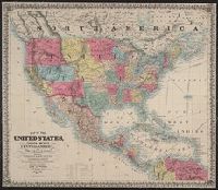
- Creator:
- Atwood, John M., b. ca. 1818
- Published / Created:
- 1851
- Call Number:
- 75 1851B
- Container / Volume:
- BRBL_00400
- Image Count:
- 1
- Resource Type:
- Maps, Atlases & Globes
- Subject (Name):
- Atwood, John M., b. ca. 1818, engraver
- Found in:
- Beinecke Rare Book and Manuscript Library > Map of the United States, Canada, Mexico, Central America, and the West India Islands : with a portion of Venezuela & New Granada; showing the routes overland and by the Isthmus to California & Oregon, also the new boundaries of California, Utah, & New Me
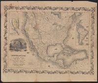
- Creator:
- Atwood, John M., b. ca. 1818
- Published / Created:
- 1849
- Call Number:
- 71 1849B
- Container / Volume:
- BRBL_00370
- Image Count:
- 1
- Resource Type:
- Maps, Atlases & Globes
- Found in:
- Beinecke Rare Book and Manuscript Library > Map of the United States, the British provinces, Mexico &c.
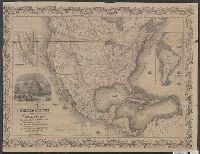
- Creator:
- Atwood, John M., b. ca. 1818
- Published / Created:
- 1849
- Call Number:
- 71 1849C
- Container / Volume:
- BRBL_00370
- Image Count:
- 1
- Resource Type:
- Maps, Atlases & Globes
- Found in:
- Beinecke Rare Book and Manuscript Library > Map of the United States, the British provinces, Mexico &c. / drawn & engraved by J.M. Atwood.
- Creator:
- Atwood, John M., b. ca. 1818
- Published / Created:
- 1856, c1848.
- Call Number:
- 754 1856
- Container / Volume:
- BRBL_00416
- Image Count:
- 1
- Resource Type:
- Maps, Atlases & Globes
- Found in:
- Beinecke Rare Book and Manuscript Library > Map of the western states / by J.M. Atwood.
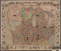
- Creator:
- Atwood, John M., b. ca. 1818
- Published / Created:
- 1848
- Call Number:
- 80 1848C
- Container / Volume:
- BRBL_00533
- Image Count:
- 1
- Resource Type:
- Maps, Atlases & Globes
- Found in:
- Beinecke Rare Book and Manuscript Library > Map of the western states / drawn & engraved by J.M. Atwood.
- Creator:
- Burr, Henry A
- Published / Created:
- 1850
- Call Number:
- 75 1850
- Container / Volume:
- BRBL_00400
- Image Count:
- 2
- Resource Type:
- Maps, Atlases & Globes
- Subject (Name):
- Atwood, John M., b. ca. 1818
- Found in:
- Beinecke Rare Book and Manuscript Library > Disturnell's new map of the United States and Canada : showing all the canals, rail roads, telegraph lines and principal stage routes / drawn by Henry A. Burr, topographer to the Post Office Dep't., Washington, D.C. ; engraved by J.M. Atwood, N.Y.
- Creator:
- Creuzbaur, Robert
- Published / Created:
- 1853
- Call Number:
- 796 1853
- Container / Volume:
- BRBL_00525
- Image Count:
- 1
- Resource Type:
- Maps, Atlases & Globes
- Subject (Name):
- Atwood, John M., b. ca. 1818
- Found in:
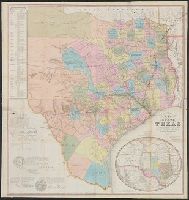
- Beinecke Rare Book and Manuscript Library > J. De Cordova's map of the state of Texas / compiled from the records of the general land office of the state by Robert Creuzbaur ; engraved by J.M. Atwood.
- Creator:
- Creuzbaur, Robert
- Published / Created:
- 1849
- Call Number:
- 796 1849B
- Container / Volume:
- BRBL_00524
- Image Count:
- 1
- Resource Type:
- Maps, Atlases & Globes
- Subject (Name):
- Atwood, John M., b. ca. 1818
- Found in:
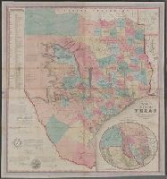
- Beinecke Rare Book and Manuscript Library > J. De Cordova's map of the state of Texas / compiled from the records of the general land office of the state by Robert Creuzbaur ; engraved by J.M. Atwood.
- Creator:
- J.H. Colton & Co
- Published / Created:
- 1852
- Call Number:
- 815 1852
- Container / Volume:
- BRBL_00560
- Image Count:
- 1
- Resource Type:
- Maps, Atlases & Globes
- Subject (Name):
- Atwood, John M., b. ca. 1818
- Found in:
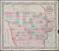
- Beinecke Rare Book and Manuscript Library > Colton's township map of the state of Iowa / compiled from the United States surveys & other authentic sources ; drawn by Geo. W. Colton ; engraved by J.M. Atwood.
- Creator:
- Colton, G. Woolworth (George Woolworth), 1827-1901
- Published / Created:
- 1858, c1846.
- Call Number:
- 771 N49 1858C
- Container / Volume:
- BRBL_00486
- Image Count:
- 1
- Resource Type:
- Maps, Atlases & Globes
- Subject (Name):
- Atwood, John M., b. ca. 1818
- Found in:
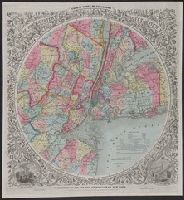
- Beinecke Rare Book and Manuscript Library > Map of the country thirty three miles around the city of New York / drawn by G.W. Colton ; engraved by J.M. Atwood.