Search
You Searched For
Search Results
- Published / Created:
- 1744
- Call Number:
- 44 1744
- Container / Volume:
- BRBL_00254
- Image Count:
- 1
- Resource Type:
- Maps, Atlases & Globes
- Subject (Geographic):
- Balkan Peninsula--Maps--Early works to
- Found in:
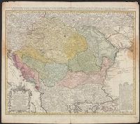
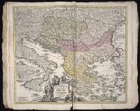
- Beinecke Rare Book and Manuscript Library > Carte d'Hongrie en general, contenant selon la division ancienne & Methodique, la Hongrie en particuliee, la Croatie, la Dalmatie, la Bosnie, la Boulgrie, la Principauté de Transylvanie, les Despotats de Walachie & de Moldav ...
- Published / Created:
- 1703
- Call Number:
- 44 1703
- Container / Volume:
- BRBL_00254
- Image Count:
- 1
- Resource Type:
- Maps, Atlases & Globes
- Subject (Geographic):
- Balkan Peninsula--Maps--Early works to
- Found in:
- Beinecke Rare Book and Manuscript Library > Carte de la Hongrie et des Pays qui en dependoient autresois ... Par Guillaume de l'Isle ... Gravé par Liebaux le fils.
- Creator:
- Valck, G. (Gerard), 1651 or 1652-1726.
- Published / Created:
- [1710?]
- Call Number:
- 1973 Folio 18
- Image Count:
- 1
- Resource Type:
- Maps, Atlases & Globes
- Subject (Geographic):
- Balkan Peninsula--Maps--Early works to
- Found in:
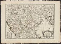
- Beinecke Rare Book and Manuscript Library > Dalmatia, Sclavonia, Croatia, Bosnia, Servia, et Istria [cartographic material] : distributa in singulares ditiones et diœceses, una cum Republica Ragusana, et circumjacentibus regionibus, Hungaria, Venetiis, statu ecclesiastico, Napoli et Macedonia / Venundantur per Gerardum et Leonardum Valk, cum Priv.
- Creator:
- Homann, Johann Baptist, 1663-1724
- Published / Created:
- 1720?
- Call Number:
- 1975 Folio 31
- Collection Title:
- [Atlas factice of 42 maps, produced by the Homann Erben firm]
- Image Count:
- 1
- Subject (Geographic):
- Balkan Peninsula --Maps --Early works
- Found in:
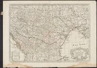
- Beinecke Rare Book and Manuscript Library > Fluviorum in Europa principis Danubii [cartographic material] : cum adiacentibus regnis nec non totius Graeciae et archipelagi novissima tabula / authore Joh. Baptista Homanno
- Creator:
- Homann, Johann Baptist, 1663-1724
- Published / Created:
- 1720?
- Call Number:
- 1973 Folio 30
- Collection Title:
- [Atlas factice of 32 maps and 1 distance table, produced by the Homann Erben firm]
- Image Count:
- 2
- Subject (Geographic):
- Balkan Peninsula --Maps --Early works
- Found in:
- Beinecke Rare Book and Manuscript Library > Fluviorum in Europa principis Danubii [cartographic material] : cum adiacentibus regnis nec non totius Graeciae et archipelagi novissima tabula / authore Joh. Baptista Homanno
- Published / Created:
- 1708
- Call Number:
- 44 1708
- Container / Volume:
- BRBL_00254
- Image Count:
- 1
- Resource Type:
- Maps, Atlases & Globes
- Subject (Geographic):
- Balkan Peninsula--Maps--Early works to
- Found in:
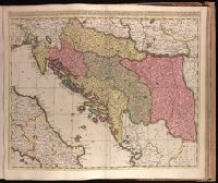
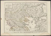
- Beinecke Rare Book and Manuscript Library > Graeciae Pars Septentrionalis. Austore Guillelmo Del'isle ...
- Published / Created:
- 1790
- Call Number:
- 44 1790
- Container / Volume:
- BRBL_00254
- Image Count:
- 2
- Resource Type:
- Maps, Atlases & Globes
- Subject (Geographic):
- Balkan Peninsula--Maps--Early works to
- Found in:
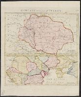
- Beinecke Rare Book and Manuscript Library > Hungary with part of Turkey. Pannonia Dacia etc. Engraved by S. Neele.
- Published / Created:
- 1770
- Call Number:
- 44 1770A
- Container / Volume:
- BRBL_00254
- Image Count:
- 1
- Resource Type:
- Maps, Atlases & Globes
- Subject (Geographic):
- Balkan Peninsula--Maps--Early works to
- Found in:
- Beinecke Rare Book and Manuscript Library > Mappa Geographica Graeciae Septentrionalis Hodiernae sive Provinciarum Macedoniae, Thessaliae et Albaniae ... D.A. Hauer Sc. Norimb.
- Creator:
- Schenk, Peter, 1660-1718 or 1719.
- Published / Created:
- ca. 1700?]
- Call Number:
- 1973 Folio 18
- Image Count:
- 1
- Resource Type:
- Maps, Atlases & Globes
- Subject (Geographic):
- Balkan Peninsula--Maps--Early works to
- Found in:
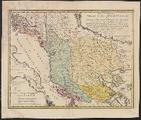
- Beinecke Rare Book and Manuscript Library > Regni Hungariae, Graeciae, Moreae, totius Danubii, adiacentiumque regnorum, nec non totius Graeciae et Archipelagi delineatio nova [cartographic material] / expressa a Petro Schenk.