Search
You Searched For
Search Results
- Published / Created:
- 1750?]
- Call Number:
- 217 1750
- Container / Volume:
- BRBL_00015
- Image Count:
- 1
- Resource Type:
- Maps, Atlases & Globes
- Subject (Geographic):
- Bermuda Islands--Maps--Early works to
- Found in:
- Beinecke Rare Book and Manuscript Library > A new and accurate map of Bermudas or Sommer's Islands, taken from an actual survey ... by Eman Bowen.
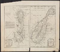
- Creator:
- Mitchell, John, 1711-1768
Zatta, Antonio, fl. 1757-1797
- Published / Created:
- 1778
- Call Number:
- 217 1778
- Image Count:
- 1
- Resource Type:
- Maps, Atlases & Globes
- Subject (Geographic):
- Bermuda Islands--Maps--Early works to
- Found in:
- Beinecke Rare Book and Manuscript Library > Le colonie unite dell' America settentr[iona]le di nuova projezione [cartographic material] / ass.ee. li Signori Riformatori dello studio di Padova, Venezia 1778 presso Antonio Zatta.
- Creator:
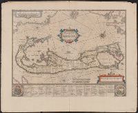
- Hondius, Hendrik, 1597-1651
- Published / Created:
- [1621]
- Call Number:
- 217 1616
- Container / Volume:
- BRBL_00682
- Image Count:
- 2
- Resource Type:
- Maps, Atlases & Globes
- Subject (Geographic):
- Bermuda Islands--Maps--Early works to
- Found in:
- Beinecke Rare Book and Manuscript Library > Mappa Aestiuarum Insularum : alias Barmudas dictarum, ad Ostia Mexicani aestuarij jace[n]tium in latitudine graduum 32 minutorum 25. ab Anglia, Londino Scilicet versus Libonotum 3300 miliaribus Anglicanis et a Roanoeck (qui locus est in Virginia) versus E
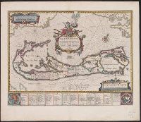
- Published / Created:
- [1633]
- Call Number:
- 217 1633
- Image Count:
- 2
- Resource Type:
- Maps, Atlases & Globes
- Subject (Geographic):
- Bermuda Islands--Maps--Early works to
- Found in:
- Beinecke Rare Book and Manuscript Library > Mappa Aestivarum insularum, alias Barmudas ...
- Published / Created:
- [1652-1653]
- Call Number:
- 217 1652
- Image Count:
- 2
- Resource Type:
- Maps, Atlases & Globes
- Subject (Geographic):
- Bermuda Islands--Maps--Early works to
- Found in:
- Beinecke Rare Book and Manuscript Library > Mappa Aestivarum insularum, alias Barmudas dictarum ...
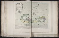
- Creator:
- Blaeu, Willem Janszoon, 1571-1638, cartographer
- Call Number:
- 217 1635
- Image Count:
- 1
- Resource Type:
- Maps, Atlases & Globes
- Subject (Geographic):
- Bermuda Islands--Maps--Early works to
- Found in:
- Beinecke Rare Book and Manuscript Library > Mappa Aestivarum insularum, alias Barmudas dictarum : ad ostia Mexicani aestuarij jacentium in latitudine graduum 32 minutorum 25 ab Anglia, Londino scilicet versus Libonotum 3300 miliaribus Anglicanis, et a Roanoack (qui locus est in Virginia) versus Eur
- Creator:
- Blaeu, Willem Janszoon, 1571-1638
- Published / Created:
- 1645-1650]
- Call Number:
- 217 1630
- Container / Volume:
- BRBL_00732
- Image Count:
- 2
- Resource Type:
- Maps, Atlases & Globes
- Subject (Geographic):
- Bermuda Islands--Maps--Early works to
- Found in:
- Beinecke Rare Book and Manuscript Library > Mappa Aestivarum insularum, alias Barmudas dictarum : ad ostia Mexicani aestuarij jacentium in latitudine graduum 32 minutorum 25 ad Anglia, Londino scilicet versus Libonotum 3300 miliaribus Anglicanis, et a Roanoack (qui locus est in Virginia) versus Eur
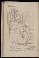
- Creator:
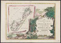
- Lempriere, C., creator
Toms, W. H. (William Henry), ca. 1700-ca. 1750
- Published / Created:
- 1738?
- Call Number:
- 2003 Folio 85
- Image Count:
- 1
- Subject (Geographic):
- Bermuda Islands -- Maps -- Early works
- Found in:
- Beinecke Rare Book and Manuscript Library > To His Excellency Alured Popple, Esq., governour of Bermuda, or the Summer Islands, this map, from a new survey correcting ye dangerous errors in all ye charts of that place hitherto publish'd
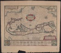
- Call Number:
- 1973 Folio 116
- Collection Title:
- The English pilot: describing the West-India navigation, from Hudson's-Bay to the river Amazones
- Image Count:
- 1
- Subject (Geographic):
- Bermuda Islands --Maps --Early works to
- Found in:
- Beinecke Rare Book and Manuscript Library > A description of the ports and islands upon the coast between the Amazones and Cape Florida
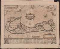
- Call Number:
- 1974 Folio 72
- Collection Title:
- The English pilot: describing the West-India navigation, from Hudson's-Bay to the river Amazones
- Image Count:
- 1
- Subject (Geographic):
- Bermuda Islands --Maps --Early works to
- Found in:
- Beinecke Rare Book and Manuscript Library > A description of the ports and islands upon the coast between the Amazons and Cape Florida