Search
You Searched For
Search Results
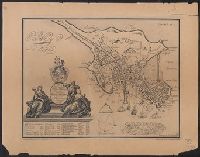
- Creator:
- Dearborn, Benjamin, 1754-1838
- Published / Created:
- [1814]
- Call Number:
- 764 B65 1814A
- Container / Volume:
- BRBL_00455
- Image Count:
- 2
- Resource Type:
- Maps, Atlases & Globes
- Subject (Geographic):
- Boston (Mass.)--Maps
- Found in:
- Beinecke Rare Book and Manuscript Library > A plan of those parts of Boston and the towns in its vicinity : with the waters and flats adjacent which are immediately or remotely connected with the contemplated design of erecting perpetual tide-mills.
- Creator:
- Walker Lith. & Pub. Co
- Published / Created:
- [1890?]
- Call Number:
- 764am B65 1890A
- Container / Volume:
- BRBL_00460
- Image Count:
- 1
- Resource Type:
- Maps, Atlases & Globes
- Subject (Geographic):
- Boston (Mass.)--Maps
- Found in:
- Beinecke Rare Book and Manuscript Library > Boston Harbor.
- Published / Created:
- 1918
- Call Number:
- 764gme B65 1918
- Container / Volume:
- BRBL_00462
- Image Count:
- 1
- Resource Type:
- Maps, Atlases & Globes
- Subject (Geographic):
- Boston (Mass.)--Maps
- Found in:
- Beinecke Rare Book and Manuscript Library > Boston Subway, East Boston Tunnel, Washington St. Tunnel, tunnel for Cambridge connection, Dorchester Tunnel, Boylston St. Subway & East Boston Tunnel Connection.
- Published / Created:
- 1875
- Call Number:
- 764hc B65 1775
- Container / Volume:
- BRBL_00462
- Image Count:
- 2
- Resource Type:
- Maps, Atlases & Globes
- Subject (Geographic):
- Boston (Mass.)--Maps
- Found in:
- Beinecke Rare Book and Manuscript Library > Bunker Hill Centennial.
- Published / Created:
- 1819
- Call Number:
- 764 B65 1819
- Container / Volume:
- BRBL_00455
- Image Count:
- 1
- Resource Type:
- Maps, Atlases & Globes
- Subject (Geographic):
- Boston (Mass.)--Maps
- Found in:
- Beinecke Rare Book and Manuscript Library > Map of Boston and its Vicinity by John G. Hales.
- Published / Created:
- 1814
- Call Number:
- 764 B65 1814
- Container / Volume:
- BRBL_00455
- Image Count:
- 1
- Resource Type:
- Maps, Atlases & Globes
- Subject (Geographic):
- Boston (Mass.)--Maps
- Found in:
- Beinecke Rare Book and Manuscript Library > Map of Boston in the State of Massachusetts. Surveyed by J.G. Hales Geogr. & surveyor. I.R. Penniman Del. Engraved by T. Wightman Jr.
- Published / Created:
- 1843
- Call Number:
- 764 B65 1843
- Container / Volume:
- BRBL_00455
- Image Count:
- 1
- Resource Type:
- Maps, Atlases & Globes
- Subject (Geographic):
- Boston (Mass.)--Maps
- Found in:
- Beinecke Rare Book and Manuscript Library > Sketch of the Battle of Bunker Hill by a British Officer.
- Published / Created:
- 1835
- Call Number:
- 764 B65 1835
- Container / Volume:
- BRBL_00455
- Image Count:
- 1
- Resource Type:
- Maps, Atlases & Globes
- Subject (Geographic):
- Boston (Mass.)--Maps
- Found in:
- Beinecke Rare Book and Manuscript Library > The South Cove territory, comprising every part which is coloured on this map.
- Creator:
- Burgis, William, active 1722-1736
- Published / Created:
- 1869
- Call Number:
- 764 B65 1729
- Container / Volume:
- BRBL_00454
- Image Count:
- 1
- Resource Type:
- Maps, Atlases & Globes
- Subject (Geographic):
- Boston (Mass.)--Maps
- Found in:
- Beinecke Rare Book and Manuscript Library > To His Excellency William Burnet, Esq., this Plan of Boston in New England is humbly dedicated / engraved by Thos. Johnson.
- Published / Created:
- [1907?]
- Call Number:
- 764am B65 1907
- Container / Volume:
- BRBL_00460
- Image Count:
- 1
- Resource Type:
- Maps, Atlases & Globes
- Subject (Geographic):
- Boston (Mass.)--Maps
- Found in:
- Beinecke Rare Book and Manuscript Library > Twentieth century Boston : the best city in the United States to live in, to do business in and to visit.