Search
You Searched For
Search Results
- Creator:
- U.S. Coast and Geodetic Survey
- Published / Created:
- [1881]
- Call Number:
- 851 1881
- Container / Volume:
- BRBL_00639
- Image Count:
- 1
- Resource Type:
- Maps, Atlases & Globes
- Subject (Name):
- --Caribbean Area--Maps
- Found in:
- Beinecke Rare Book and Manuscript Library > Chart of part of the Bahama Islands showing the tracks ascribed to Columbus on his discovery of the New World / compiled and drawn, under the direction of W.T. Bright, in charge of Drawing Division, U.S. Coast and Geodetic Survey Office ; by T.J. O'Sulliv
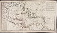
- Creator:
- Reichard, C. G. (Christian Gottlieb), 1758-1837
- Published / Created:
- 1802
- Call Number:
- 71 1802B
- Container / Volume:
- BRBL_00367
- Image Count:
- 1
- Resource Type:
- Maps, Atlases & Globes
- Subject (Geographic):
- Caribbean Area--Maps
- Found in:
- Beinecke Rare Book and Manuscript Library > Charte von Nordamerica : nach den neuesten Bestimmungen und Entdeckungen / von C.G. Reichard.
- Published / Created:
- 1898
- Call Number:
- 85 1898
- Container / Volume:
- BRBL_00638
- Image Count:
- 1
- Resource Type:
- Maps, Atlases & Globes
- Subject (Geographic):
- Caribbean Area--Maps
- Found in:
- Beinecke Rare Book and Manuscript Library > The Evening Post Map of the West Indies.
- Creator:
- Boynton, George W., d. 1884
- Published / Created:
- 1838]
- Call Number:
- 85 1838
- Container / Volume:
- BRBL_00694
- Image Count:
- 1
- Resource Type:
- Maps, Atlases & Globes
- Subject (Geographic):
- Caribbean Area--Maps
- Found in:
- Beinecke Rare Book and Manuscript Library > West Indies / [cartographic material] / engraved by G.W. Boynton.
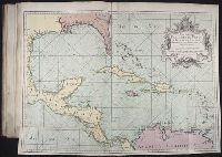
- Creator:
- Buache, Philippe, 1700-1773
- Published / Created:
- [1740]
- Call Number:
- 85 1740B
- Container / Volume:
- BRBL_00693
- Image Count:
- 1
- Resource Type:
- Maps, Atlases & Globes
- Subject (Geographic):
- Caribbean Area--Maps--Early works to
- Found in:
- Beinecke Rare Book and Manuscript Library > Carte d'une partie de l'Amérique [cartographic material] : pour la navigation des isles et du Golfe du Mexique avec l'interieur des terres depuis la Bermude jusqu'a Cayenne, partie meridionale, reduite de la carte angloise en 20 feuilles / par Mr. Popple
- Creator:
- Cruz Cano y Olmedilla, Juan de la, d. 1790
Lopez de Vargas Machuca, Tomas, 1731-1802, creator
- Published / Created:
- 1755
- Call Number:
- 2003 Folio 85
- Image Count:
- 1
- Subject (Geographic):
- Caribbean Area -- Maps -- Early works
- Found in:
- Beinecke Rare Book and Manuscript Library > Mapa maritimo del Golfo de Mexico e islas de la America: para el uso de los navegantes en esta parte del mundo, construido sobre las mexores memorias, y observaciones astronomicas de longitudes, y latitudes
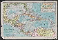
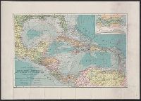
- Creator:
- American Bank Note Company
- Published / Created:
- c1913.
- Call Number:
- 85 1913
- Container / Volume:
- BRBL_00638
- Image Count:
- 1
- Resource Type:
- Maps, Atlases & Globes
- Subject (Geographic):
- Caribbean Area--Maps
- Found in:
- Beinecke Rare Book and Manuscript Library > Map of Central America, Cuba, Porto Rico, and the islands of the Caribbean Sea / prepared by the American Bank Note Co. ; Gilbert H. Grosvenor, editor.
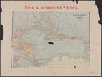
- Creator:
- George F. Cram Company
- Published / Created:
- [191-?]
- Call Number:
- 85 1910
- Container / Volume:
- BRBL_00638
- Image Count:
- 2
- Resource Type:
- Maps, Atlases & Globes
- Subject (Geographic):
- Caribbean Area--Maps
- Found in:
- Beinecke Rare Book and Manuscript Library > Showing Spanish possessions in West Indies ; Showing Spanish possessions in East Indies.
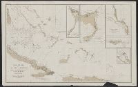
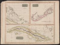
- Published / Created:
- 1816
- Call Number:
- 851 1816
- Container / Volume:
- BRBL_00694
- Image Count:
- 1
- Resource Type:
- Maps, Atlases & Globes
- Subject (Geographic):
- Caribbean Area--Maps
- Found in:
- Beinecke Rare Book and Manuscript Library > Chart of the Bahama Islands [cartographic material] : The Bermudas or Summer Islands ; Island of Cuba.