Search
You Searched For
Search Results
- Creator:
- Maury, Matthew Fontaine, 1806-1873
- Published / Created:
- 1859 [i.e. 1860]
- Call Number:
- 11cfk 1850B-2
- Container / Volume:
- BRBL_00770
- Image Count:
- 1
- Resource Type:
- Maps, Atlases & Globes
- Subject (Geographic):
- Indian Ocean--Maps
- Subject (Topic):
- Monsoons--Indian Ocean--Maps
- Found in:
- Beinecke Rare Book and Manuscript Library > Monsoon & trade wind chart of the Indian Ocean [cartographic material] / by M.F. Maury, L.L.D. Comr. U.S.N., Superintendent of U.S.N. Observatory ; compiled by Lieuts. J.J. Guthrie ... [et al.] ; and projected by Lt. R.L. May from materials in the Bureau of Ordnance and Hydrography, Captain D.N. Ingraham, Chief of the Bureau.
- Creator:
- Maury, Matthew Fontaine, 1806-1873
- Published / Created:
- 1859
- Call Number:
- 11cfk 1850C-10
- Container / Volume:
- BRBL_00772
- Image Count:
- 3
- Resource Type:
- Maps, Atlases & Globes
- Subject (Geographic):
- Indian Ocean--Maps
- Subject (Topic):
- Winds--Indian Ocean--Maps
- Found in:
- Beinecke Rare Book and Manuscript Library > Pilot chart of the South Indian Ocean / by M.F. Maury, L.L.D. Comdr. U.S. Navy, Superin'dt. of U.S.N. Observatory, Washington ; compiled from materials in the Bureau of Ordnance and Hydrography by Lieuts. J.J. Guthrie, W.C. West & J.H. Carter, U.S.N.
- Creator:
- Maury, Matthew Fontaine, 1806-1873
- Published / Created:
- 1855
- Call Number:
- 11cfk 1850C-11
- Container / Volume:
- BRBL_00772
- Image Count:
- 1
- Resource Type:
- Maps, Atlases & Globes
- Subject (Geographic):
- Indian Ocean--Maps
- Subject (Topic):
- Winds--Indian Ocean--Maps
- Found in:
- Beinecke Rare Book and Manuscript Library > Pilot chart of the north Indian Ocean [cartographic material] / by M.F. Maury, L.L.D. Lieut. U.S. Navy, Superin'dt. of U.S.N. Observatory ; compiled from materials in the Bureau of Ordnance and Hydrography by Lieuts. W.B. Fitzgerald & Wm. C. West, U.S.N, Commodore Charles Morris, Chief of Bureau.
- Published / Created:
- 1812
- Call Number:
- 29 1812
- Container / Volume:
- BRBL_00028
- Image Count:
- 1
- Resource Type:
- Maps, Atlases & Globes
- Subject (Geographic):
- Indian Ocean--Maps
- Found in:
- Beinecke Rare Book and Manuscript Library > A Chart of the Great Ethiopian Archipelago in the Indian Seas ... M.D. Apres. For the History of Mauritus by Ch. Grant ... 1801 S.J. Neele Sculp. 1812.
- Published / Created:
- 1842
- Call Number:
- 29cea 1842
- Container / Volume:
- BRBL_00028
- Image Count:
- 2
- Resource Type:
- Maps, Atlases & Globes
- Subject (Geographic):
- Indian Ocean--Maps
- Found in:
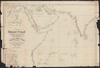
- Beinecke Rare Book and Manuscript Library > Chart of the Indian Ocean from the Cape of Good Hope to Calcutta, Including the Red Sea and the Persian Gulf; Compiled from the most recent Surveys of the East India Company's Officers and those of the Royal Navy by John Walker, geographer to the East Ind
- Creator:
- Groll, Max, 1876-1916
- Published / Created:
- [1911?]
- Call Number:
- 29ceh 1911
- Container / Volume:
- BRBL_00028
- Image Count:
- 1
- Resource Type:
- Maps, Atlases & Globes
- Subject (Geographic):
- Indian Ocean--Maps
- Found in:
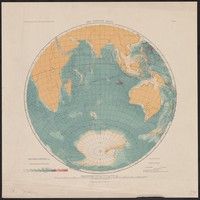
- Beinecke Rare Book and Manuscript Library > Der Indische Ozean [cartographic material] / Institut für Meereskunde der Universität Berlin ; gezeichnet von Dr. M. Groll ; Geogr. lith. Anst. u. Steindr. v. C.L. Keller, Berlin S.
- Creator:
- Edinburgh Geographical Institute
John Bartholomew & Co
- Published / Created:
- 1920?]
- Call Number:
- 29 1920
- Image Count:
- 1
- Resource Type:
- Maps, Atlases & Globes
- Subject (Geographic):
- Indian Ocean--Maps
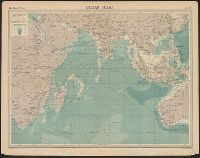
- Found in:
- Beinecke Rare Book and Manuscript Library > Indian Ocean [cartographic material] / the Edinburgh Geographical Institute ; John Bartholomew & Co.
- Creator:
- Maury, Matthew Fontaine, 1806-1873
- Published / Created:
- [1854?]-1856.
- Call Number:
- 11cfk 1850A-5
- Container / Volume:
- BRBL_00769
- Image Count:
- 8
- Resource Type:
- Maps, Atlases & Globes
- Subject (Geographic):
- Indian Ocean--Maps
- Found in:
- Beinecke Rare Book and Manuscript Library > Maury's wind and current chart, Indian Ocean [cartographic material].
- Published / Created:
- 1767
- Call Number:
- 29 1767
- Container / Volume:
- BRBL_00028
- Image Count:
- 1
- Resource Type:
- Maps, Atlases & Globes
- Subject (Geographic):
- Indian Ocean--Maps--Early works to 1800
- Found in:
- Beinecke Rare Book and Manuscript Library > Carte réduite de l'ocean oriental, ou mer des Indes ... / par M. Bellin ...