Search
You Searched For
Search Results
- Creator:
- Rand McNally and Company
- Published / Created:
- c1919.
- Call Number:
- 805 1919
- Container / Volume:
- BRBL_00546
- Image Count:
- 2
- Resource Type:
- Maps, Atlases & Globes
- Alternative Title:
- New commercial atlas map of Indiana
- Subject (Geographic):
- Indiana--Maps
- Subject (Topic):
- Railroads--Indiana--Maps
- Found in:
- Beinecke Rare Book and Manuscript Library > Rand-McNally indexed pocket map and shippers' guide of Indiana : railroads, electric lines, post offices, express, telegraph and mail service ... / Rand McNally & Co.
- Published / Created:
- [1847]
- Call Number:
- 805fcm 1847
- Container / Volume:
- BRBL_00546
- Image Count:
- 1
- Resource Type:
- Maps, Atlases & Globes
- Subject (Geographic):
- Indiana--Maps
- Found in:
- Beinecke Rare Book and Manuscript Library > A sketch of the Public Surveys in Indiana.
- Published / Created:
- 1866
- Call Number:
- 805 1866
- Container / Volume:
- BRBL_00546
- Image Count:
- 1
- Resource Type:
- Maps, Atlases & Globes
- Subject (Geographic):
- Indiana--Maps
- Found in:
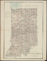
- Beinecke Rare Book and Manuscript Library > Johnson's Indiana.
- Published / Created:
- 1874
- Call Number:
- 805ca J135 1874
- Container / Volume:
- BRBL_00546
- Image Count:
- 1
- Resource Type:
- Maps, Atlases & Globes
- Subject (Geographic):
- Indiana--Maps
- Found in:
- Beinecke Rare Book and Manuscript Library > Map of Jackson County Indiana. / prepared for the sixth annual report of E.T. Cox, state geologist.
- Call Number:
- 805fcm C723 1841
- Container / Volume:
- BRBL_00546
- Image Count:
- 1
- Resource Type:
- Maps, Atlases & Globes
- Subject (Geographic):
- Indiana--Maps
- Found in:
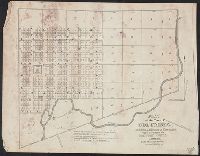
- Beinecke Rare Book and Manuscript Library > Plat of the Town of Columbia ... Whitley county. Elihu Chauncey, Proprietor.
- Creator:
- Roeser, C. (Charles)
- Published / Created:
- 1878
- Call Number:
- 805 1878
- Container / Volume:
- BRBL_00546
- Image Count:
- 1
- Resource Type:
- Maps, Atlases & Globes
- Subject (Geographic):
- Indiana--Maps
- Found in:
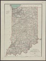
- Beinecke Rare Book and Manuscript Library > State of Indiana / compiled from the official records of the General Land Office and other sources by C. Roeser, principal draughtsman, G.L.O.
- Creator:
- Hendges, M. (Matthew)
- Published / Created:
- 1886
- Call Number:
- 805 1886
- Container / Volume:
- BRBL_00546
- Image Count:
- 1
- Resource Type:
- Maps, Atlases & Globes
- Subject (Geographic):
- Indiana--Maps
- Found in:
- Beinecke Rare Book and Manuscript Library > State of Indiana / compiled from the official records of the General Land Office and other sources by Geo. U. Mayo, chief of Draughting Div., G.L.O. ; drawn by M. Hendges.
- Published / Created:
- [1841?]
- Call Number:
- 805fcm B446 1841
- Container / Volume:
- BRBL_00717
- Image Count:
- 1
- Resource Type:
- Maps, Atlases & Globes
- Subject (Geographic):
- Indiana--Maps, Manuscript
- Found in:
- Beinecke Rare Book and Manuscript Library > [Manuscript map of a plat of Benton County].
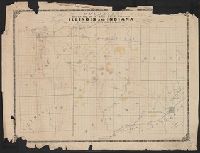
- Published / Created:
- 1859
- Call Number:
- 805fcm 1859
- Container / Volume:
- BRBL_00546
- Image Count:
- 1
- Resource Type:
- Maps, Atlases & Globes
- Subject (Geographic):
- Indiana--Maps
- Found in:
- Beinecke Rare Book and Manuscript Library > Counties bordering on state line between Illinois and Indiana / Wm. S. Peckham, real estate agent, Lafayette Ind.
- Published / Created:
- [1905].
- Call Number:
- 805gmb T277 1905
- Container / Volume:
- BRBL_00546
- Image Count:
- 1
- Resource Type:
- Maps, Atlases & Globes
- Subject (Geographic):
- Terre Haute (Indiana)--Maps
- Found in:
- Beinecke Rare Book and Manuscript Library > Map of the city of Terre Haute, Indiana.