Search
You Searched For
Search Results
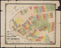
- Creator:
- Tyler, Henry Dunreath
- Published / Created:
- [approximately 1897?]
- Call Number:
- 771 1897A
- Container / Volume:
- BRBL_00479
- Image Count:
- 1
- Resource Type:
- Maps, Atlases & Globes
- Subject (Geographic):
- Manhattan (New York, N.Y.)--Maps
- Found in:
- Beinecke Rare Book and Manuscript Library > Map of the original grants of village lots from the Dutch West India Company to the inhabitants of New-Amsterdam (now New-York) lying below the present line of Wall Street : grants commencing A.D. 1642 / [by Henry Dunreath Tyler].
- Published / Created:
- 1897
- Call Number:
- 771 N49 1897B
- Container / Volume:
- BRBL_00489
- Image Count:
- 1
- Resource Type:
- Maps, Atlases & Globes
- Subject (Geographic):
- Manhattan (New York, N.Y.)--Maps
- Found in:
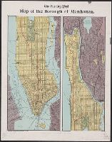
- Beinecke Rare Book and Manuscript Library > The Evening post map of the borough of Manhattan.
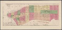
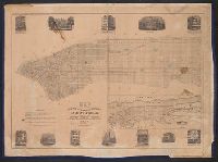
- Creator:
- Ferd. Mayer & Co.
- Published / Created:
- [1860?]
- Call Number:
- 771 N49 1860B
- Container / Volume:
- BRBL_00486
- Image Count:
- 1
- Resource Type:
- Maps, Atlases & Globes
- Subject (Geographic):
- Manhattan (New York, N.Y.)--Maps
- Found in:
- Beinecke Rare Book and Manuscript Library > [Manhattan from the Battery to 112th Street].
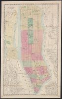
- Creator:
- Dripps, M. (Matthew)
- Published / Created:
- 1866
- Call Number:
- 771 N49 1866
- Container / Volume:
- BRBL_00487
- Image Count:
- 1
- Resource Type:
- Maps, Atlases & Globes
- Subject (Geographic):
- Manhattan (New York, N.Y.)--Maps
- Found in:
- Beinecke Rare Book and Manuscript Library > Map of New York and vicinity.
- Creator:
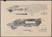
- Pierce, F. E. (Frederick Erastus), 1878-1935
- Published / Created:
- 1894
- Call Number:
- 771ea N49 1894
- Container / Volume:
- BRBL_00493
- Image Count:
- 2
- Resource Type:
- Maps, Atlases & Globes
- Subject (Geographic):
- Manhattan (New York, N.Y.)--Population
- Found in:
- Beinecke Rare Book and Manuscript Library > The Tenement-House Committee maps / drawn by Frederick E. Pierce.
- Creator:
- Hobbs, C. W
- Published / Created:
- 1880
- Call Number:
- 771 N49 1880
- Container / Volume:
- BRBL_00488
- Image Count:
- 1
- Resource Type:
- Maps, Atlases & Globes
- Subject (Geographic):
- Manhattan (New York, N.Y.)--Maps
- Subject (Topic):
- Docks--New York (State)--Manhattan (N.Y
- Found in:
- Beinecke Rare Book and Manuscript Library > Citizens & travelers guide map into and from the City of New York and adjacent places.
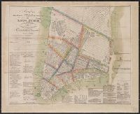
- Creator:
- Hooker, William, 1782-1856
- Call Number:
- 771 N49 1828
- Container / Volume:
- BRBL_00485
- Image Count:
- 1
- Resource Type:
- Maps, Atlases & Globes
- Subject (Geographic):
- Manhattan (New York, N.Y.)--Maps
- Found in:
- Beinecke Rare Book and Manuscript Library > Hooker's new pocket plan of the city of New York / compiled & surveyed by William Hooker, A.C.S.A., hydrographer & engraver.
- Published / Created:
- 1850
- Call Number:
- 771 N49 1850
- Container / Volume:
- BRBL_00485
- Image Count:
- 1
- Resource Type:
- Maps, Atlases & Globes
- Subject (Geographic):
- Manhattan (New York, N.Y.)--Maps
- Found in:
- Beinecke Rare Book and Manuscript Library > Map of the city and county and environs of New-York : with original characters and illustrations, embracing all the official alterations and improvements for the year 1850.
- Creator:
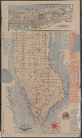
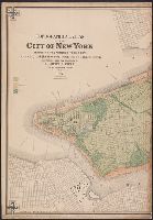
- Viele, Egbert L. (Egbert Ludovicus), 1825-1902
- Published / Created:
- 1874
- Call Number:
- 771 N49 1874
- Container / Volume:
- BRBL_00488
- Image Count:
- 5
- Resource Type:
- Maps, Atlases & Globes
- Subject (Geographic):
- Manhattan (New York, N.Y.)--Maps
- Found in:
- Beinecke Rare Book and Manuscript Library > Topographical atlas of the City of New York including the annexed territory, showing original water courses and made land / prepared under the direction of Egbert L. Viele ; Eugene Quackenbush ; Julius Bien photo lith.
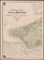
- Creator:
- Viele, Egbert L. (Egbert Ludovicus), 1825-1902
- Published / Created:
- 1874
- Call Number:
- 771 N49 1874
- Container / Volume:
- BRBL_00488
- Image Count:
- 5
- Resource Type:
- Maps, Atlases & Globes
- Subject (Geographic):
- Manhattan (New York, N.Y.)--Maps
- Found in:
- Beinecke Rare Book and Manuscript Library > Topographical atlas of the City of New York including the annexed territory, showing original water courses and made land / prepared under the direction of Egbert L. Viele ; Eugene Quackenbush ; Julius Bien photo lith.