Search
You Searched For
Search Results
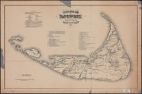
- Published / Created:
- [1821?]
- Call Number:
- 7645cea 1821
- Container / Volume:
- BRBL_00463
- Image Count:
- 1
- Resource Type:
- Maps, Atlases & Globes
- Subject (Geographic):
- Nantucket (Mass.)--Maps
- Found in:
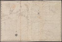
- Beinecke Rare Book and Manuscript Library > A New Chart of Nantucket Shoals & George's Bank with the adjacent coast drawn from the latest authorities. 2nd Edition. By Samuel Lambert. Salem. Cushing, Appleton & S. Lambert, of the State of Mass. Corrected June 1821.
- Published / Created:
- 1848
- Call Number:
- 7645cea 1848
- Container / Volume:
- BRBL_00463
- Image Count:
- 1
- Resource Type:
- Maps, Atlases & Globes
- Subject (Geographic):
- Nantucket (Mass.)--Maps
- Found in:
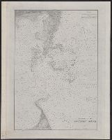
- Beinecke Rare Book and Manuscript Library > Nantucket Harbor. From a trigonometrical survey under the direction of A.D. Bache ... Survey of the Coast of the United States ... Published in 1848.
- Published / Created:
- 1791
- Call Number:
- 7645cea 1791
- Container / Volume:
- BRBL_00463
- Image Count:
- 1
- Resource Type:
- Maps, Atlases & Globes
- Subject (Geographic):
- Nantucket (Mass.)--Maps--Early works to
- Found in:
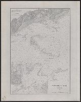
- Beinecke Rare Book and Manuscript Library > A chart of Nantucket Shoals by Capt. Paul Pinkham.
- Creator:
- United States Coast Survey
- Published / Created:
- 1883
- Call Number:
- 7645cea 1883
- Container / Volume:
- BRBL_00463
- Image Count:
- 1
- Resource Type:
- Maps, Atlases & Globes
- Subject (Geographic):
- Nantucket Sound (Mass.)--Maps
- Found in:
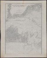
- Beinecke Rare Book and Manuscript Library > Entrance to Nantucket Sound / United States Coast Survey.
- Creator:
- United States Coast Survey
- Published / Created:
- 1883
- Call Number:
- 7645cea 1883A
- Container / Volume:
- BRBL_00463
- Image Count:
- 1
- Resource Type:
- Maps, Atlases & Globes
- Subject (Geographic):
- Nantucket Sound (Mass.)--Maps
- Found in:
- Beinecke Rare Book and Manuscript Library > Nantucket Sound Western Part / United States Coast Survey.
- Creator:
- United States Coast Survey
- Published / Created:
- 1883
- Call Number:
- 7645cea 1883B
- Container / Volume:
- BRBL_00463
- Image Count:
- 1
- Resource Type:
- Maps, Atlases & Globes
- Subject (Geographic):
- Nantucket Sound (Mass.)--Maps
- Found in:
- Beinecke Rare Book and Manuscript Library > Nantucket and Vineyard Sounds : from Cross Rip to Nobska Point / United States Coast Survey.
- Creator:
- Ewer, Ferdinand C. (Ferdinand Cartwright), 1826-1883
- Published / Created:
- 1869
- Call Number:
- 7645 1869
- Container / Volume:
- BRBL_00463
- Image Count:
- 1
- Resource Type:
- Maps, Atlases & Globes
- Subject (Geographic):
- Nantucket Island (Mass.)--Maps
- Found in:
- Beinecke Rare Book and Manuscript Library > Historical map of Nantucket / surveyed and drawn by the Rev. F.C. Ewer, D.D., 1869.
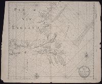
- Call Number:
- 1973 Folio 76
- Collection Title:
- The English pilot: describing the sea-coasts, capes, head-lands, rivers, bays, roads, havens
- Image Count:
- 1
- Subject (Geographic):
- Nantucket (Mass.) --Maps
- Found in:
- Beinecke Rare Book and Manuscript Library > Part of New England