Search
You Searched For
Search Results
- Published / Created:
- April 1759.
- Call Number:
- 773 C884 1759
- Container / Volume:
- BRBL_00714
- Image Count:
- 1
- Resource Type:
- Maps, Atlases & Globes
- Subject (Topic):
- --Maps--Early works to 1800
- Found in:
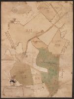
- Beinecke Rare Book and Manuscript Library > A map of Isaac Cowgill's plantation : contain two hundred & seven acres and twenty perches / by Jno. Oliver.
- Published / Created:
- 1780]
- Call Number:
- 773 1778D
- Container / Volume:
- BRBL_00690
- Image Count:
- 1
- Resource Type:
- Maps, Atlases & Globes
- Subject (Geographic):
- New Jersey--Maps--Early works to 1800
- Found in:
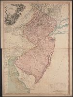
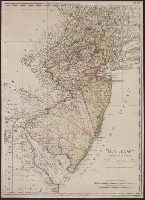
- Beinecke Rare Book and Manuscript Library > A new and accurate map of New Jersey [cartographic material] : from the best authorities.
- Creator:
- Doolittle, Amos, 1754-1832
- Published / Created:
- 1796]
- Call Number:
- 773 1790
- Container / Volume:
- BRBL_00690
- Image Count:
- 1
- Resource Type:
- Maps, Atlases & Globes
- Subject (Geographic):
- New Jersey--Maps--Early works to 1800
- Found in:
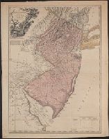
- Beinecke Rare Book and Manuscript Library > New Jersey / [cartographic material] / engraved by A. Doolittle, Newhaven.
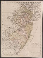
- Creator:
- Faden, William, 1749-1836
- Published / Created:
- 1778
- Call Number:
- 773 1778B
- Container / Volume:
- BRBL_00495
- Image Count:
- 1
- Resource Type:
- Maps, Atlases & Globes
- Subject (Geographic):
- New Jersey--Maps--Early works to 1800
- Found in:
- Beinecke Rare Book and Manuscript Library > The province of New Jersey divided into east and west, commonly called the Jerseys / engraved ... by Wm. Faden.
- Published / Created:
- 1777
- Call Number:
- 773 1777
- Container / Volume:
- BRBL_00495
- Image Count:
- 1
- Resource Type:
- Maps, Atlases & Globes
- Subject (Geographic):
- New Jersey--Maps--Early works to 1800
- Found in:
- Beinecke Rare Book and Manuscript Library > The province of New Jersey divided into east and west, commonly called the Jerseys / engraved ... by Wm. Faden.
- Published / Created:
- [between 1693 and 1710?]
- Call Number:
- 783 1711
- Container / Volume:
- BRBL_00691
- Image Count:
- 1
- Resource Type:
- Maps, Atlases & Globes
- Subject (Topic):
- Coasts--New Jersey--Maps--Early works
- Found in:
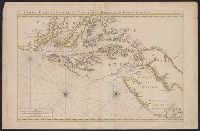
- Beinecke Rare Book and Manuscript Library > Carte particuliere de Virginie, Maryland, Pennsilvanie, la Nouvelle Iarsey orient et occidentale.
- Published / Created:
- 1784
- Call Number:
- 773hc EL48 1780
- Container / Volume:
- BRBL_00497
- Image Count:
- 1
- Resource Type:
- Maps, Atlases & Globes
- Subject (Geographic):
- New Jersey--Maps--Early works to 1800
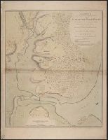
- Found in:
- Beinecke Rare Book and Manuscript Library > Sketch of the position of the British forces at Elizabeth Town point after their return from Connecticut farm, in the province of East Jersey: under the command of his excelly. Leiutt. Genl. Knyphausen, on the 8th June 1780 / by John Hills ...
- Creator:
- Kitchin, Thomas, 1718-1784
- Published / Created:
- 1756
- Call Number:
- 755 1765A
- Container / Volume:
- BRBL_00690
- Image Count:
- 1
- Resource Type:
- Maps, Atlases & Globes
- Subject (Geographic):
- New Jersey--Maps--Early works to 1800
- Found in:
- Beinecke Rare Book and Manuscript Library > A map of the eastern part of the Province of New York : with part of New Jersey &c. / drawn from the best authorities by T. Kitchin geogr.
- Creator:
- Sotzmann, D. F
- Published / Created:
- 1797
- Call Number:
- 773 1797
- Container / Volume:
- BRBL_00690
- Image Count:
- 1
- Resource Type:
- Maps, Atlases & Globes
- Subject (Geographic):
- New Jersey--Maps--Early works to 1800
- Found in:
- Beinecke Rare Book and Manuscript Library > New Jersey / entworfen von D.F. Sotzmann.
- Creator:
- Sotzmann, D. F
- Published / Created:
- 1797
- Call Number:
- 773 1797
- Container / Volume:
- BRBL_00729
- Image Count:
- 1
- Resource Type:
- Maps, Atlases & Globes
- Subject (Geographic):
- New Jersey--Maps--Early works to 1800
- Found in:
- Beinecke Rare Book and Manuscript Library > New Jersey / entworfen von D.F. Sotzmann.