Search
You Searched For
Search Results
- Creator:
- Faden, William, 1749-1836
- Published / Created:
- Octr. 19th, 1776.
- Call Number:
- 771 N49 1776K
- Container / Volume:
- BRBL_00484
- Image Count:
- 1
- Resource Type:
- Maps, Atlases & Globes
- Subject (Topic):
- ., 1776--Maps--Early works to 1800
- Found in:
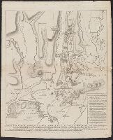
- Beinecke Rare Book and Manuscript Library > A plan of New York Island, with part of Long Island, Staten Island & east New Jersey : with a particular description of the engagement on the woody heights of Long Island, between Flatbush and Brooklyn, on the 27th of August 1776 between His Majesty's for
- Published / Created:
- [1909?]
- Call Number:
- 771 N49 1609
- Image Count:
- 1
- Resource Type:
- Maps, Atlases & Globes
- Subject (Geographic):
- New York (N.Y.)--Maps--Early works to
- Found in:
- Beinecke Rare Book and Manuscript Library > 1609 The Island of Manhattan (Mannahtin) at the time of its discovery ... L.L. Coates Engr'g Co., N.Y.
- Published / Created:
- [1909?]
- Call Number:
- 771 N49 1783
- Container / Volume:
- BRBL_00484
- Image Count:
- 1
- Resource Type:
- Maps, Atlases & Globes
- Subject (Geographic):
- New York (N.Y.)--Maps--Early works to
- Found in:
- Beinecke Rare Book and Manuscript Library > 1783 Manhattan Island at the close of the Revolution showing the American City with its Landmarks ... Fortifications ... L.L. Poates Engr'g Co., N.Y.
- Published / Created:
- [1710]
- Call Number:
- 771cea 1710
- Container / Volume:
- BRBL_00493
- Image Count:
- 1
- Resource Type:
- Maps, Atlases & Globes
- Subject (Geographic):
- New York (N.Y.)--Maps--Early works to
- Found in:
- Beinecke Rare Book and Manuscript Library > A Chart of the Sea Coasts of New Neder Land, Virginia, New England and Penn-Silvania with the city of Philadelphia from Boston to Cabo Karrit.
- Published / Created:
- 1797
- Call Number:
- 771 N49 1797
- Container / Volume:
- BRBL_00484
- Image Count:
- 1
- Resource Type:
- Maps, Atlases & Globes
- Subject (Geographic):
- New York (N.Y.)--Maps--Early works to
- Found in:
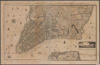
- Beinecke Rare Book and Manuscript Library > A New & Accurate Plan of the City of New York in the State of New York in North America. Published in 1797.
- Published / Created:
- [1737?] [1758?]
- Call Number:
- 771 N49 1737
- Container / Volume:
- BRBL_00484
- Image Count:
- 1
- Resource Type:
- Maps, Atlases & Globes
- Subject (Geographic):
- New York ( N.Y.)--Maps--Early works to
- Found in:
- Beinecke Rare Book and Manuscript Library > A draught of New York from the Hook to New York Town by Mark Tiddeman. Printed for W. Mount and T. Page upon Tower Hill Lomdon
- Published / Created:
- 1766
- Call Number:
- 771 N49 1766
- Container / Volume:
- BRBL_00484
- Image Count:
- 1
- Resource Type:
- Maps, Atlases & Globes
- Subject (Geographic):
- New York (N.Y.)--Maps--Early works to
- Found in:
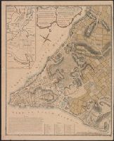
- Beinecke Rare Book and Manuscript Library > A plan of the City of New York and its environs ... John Montresor Engineer.
- Published / Created:
- 1766
- Call Number:
- 771 N49 1766
- Container / Volume:
- BRBL_00484
- Image Count:
- 1
- Resource Type:
- Maps, Atlases & Globes
- Subject (Geographic):
- New York (N.Y.)--Maps--Early works to
- Found in:
- Beinecke Rare Book and Manuscript Library > A plan of the City of New York and its environs ... John Montresor Engineer.
- Published / Created:
- 1728
- Call Number:
- 771 N49 1728T
- Container / Volume:
- BRBL_00484
- Image Count:
- 1
- Resource Type:
- Maps, Atlases & Globes
- Subject (Geographic):
- New York (N.Y.)--Maps--Early works to
- Found in:
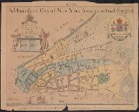
- Beinecke Rare Book and Manuscript Library > A plan of the City of New York from an actual Survey made by James Lyne ... by Wm. Bradford.
- Published / Created:
- 1728
- Call Number:
- 771 N49 1728S
- Container / Volume:
- BRBL_00484
- Image Count:
- 1
- Resource Type:
- Maps, Atlases & Globes
- Subject (Geographic):
- New York (N.Y.)--Maps--Early works to
- Found in:
- Beinecke Rare Book and Manuscript Library > A plan of the City of New York from an actual Survey made by James Lyne ... by Wm. Bradford.