Search
You Searched For
Search Results
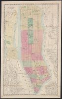
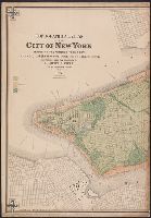
- Creator:
- Dripps, M. (Matthew)
- Published / Created:
- 1866
- Call Number:
- 771 N49 1866
- Container / Volume:
- BRBL_00487
- Image Count:
- 1
- Resource Type:
- Maps, Atlases & Globes
- Description:
- Hoboken in Hudson County (N.J.) New York (N.Y
- Subject (Geographic):
- Manhattan (New York, N.Y.)--Maps
- Subject (Topic):
- Piers--New York (State)--New York--Maps
- Found in:
- Beinecke Rare Book and Manuscript Library > Map of New York and vicinity.
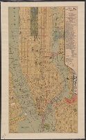
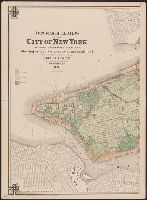
- Published / Created:
- ca. 1880]
- Call Number:
- 771 N49 1880M
- Container / Volume:
- BRBL_00488
- Image Count:
- 1
- Resource Type:
- Maps, Atlases & Globes
- Alternative Title:
- Map of New York City presented by the
- Subject (Geographic):
- New York (N.Y.)--Maps
- Subject (Topic):
- Ferries--New York (State)--New York
- Found in:
- Beinecke Rare Book and Manuscript Library > New York City.
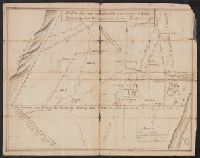
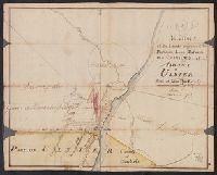
- Published / Created:
- 1765
- Call Number:
- 771 Al13 1765
- Container / Volume:
- BRBL_00713
- Image Count:
- 2
- Resource Type:
- Maps, Atlases & Globes
- Description:
- manuscript New York maps.
- Found in:
- Beinecke Rare Book and Manuscript Library > A Map of the Lands on the Southside of the County of Albany between the Blue Mountains and the Sawkill. Surred in the month of Oct. 1765, by Will Cockburn.
- Creator:
- Dripps, M. (Matthew)
- Published / Created:
- 1868
- Call Number:
- 771 N49 1868D
- Container / Volume:
- BRBL_00487
- Image Count:
- 21
- Resource Type:
- Maps, Atlases & Globes
- Subject (Geographic):
- New York (N.Y.)--Maps
- Subject (Topic):
- Landowners--New York (State)--New York
- Found in:
- Beinecke Rare Book and Manuscript Library > Plan of New York City from the Battery to Spuyten Duyvil Creek : showing every lot and building thereon; old farm lines, street numbers at the corners of blocks, railroads, steamboat landings, bulkhead and pier lines, etc., etc., etc. / based on the surve
- Published / Created:
- 1910?]
- Call Number:
- 771 N49 1910A
- Image Count:
- 1
- Resource Type:
- Maps, Atlases & Globes
- Subject (Geographic):
- Brooklyn (New York, N.Y.)--Maps
- Subject (Topic):
- Piers--New York (State)--New York--Maps
- Found in:
- Beinecke Rare Book and Manuscript Library > Guide map of the Borough of Brooklyn, Kings County, New York.
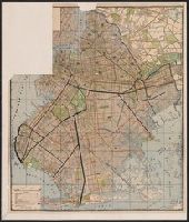
- Creator:
- Viele, Egbert L. (Egbert Ludovicus), 1825-1902
- Published / Created:
- 1874
- Call Number:
- 771 N49 1874
- Container / Volume:
- BRBL_00488
- Image Count:
- 5
- Resource Type:
- Maps, Atlases & Globes
- Subject (Geographic):
- Bronx (New York, N.Y.)--Maps
- Subject (Topic):
- )--New York--Maps
- Found in:
- Beinecke Rare Book and Manuscript Library > Topographical atlas of the City of New York including the annexed territory, showing original water courses and made land / prepared under the direction of Egbert L. Viele ; Eugene Quackenbush ; Julius Bien photo lith.
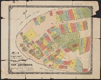
- Creator:
- Tyler, Henry Dunreath
- Published / Created:
- [approximately 1897?]
- Call Number:
- 771 1897A
- Container / Volume:
- BRBL_00479
- Image Count:
- 1
- Resource Type:
- Maps, Atlases & Globes
- Subject (Geographic):
- Manhattan (New York, N.Y.)--Maps
- Subject (Topic):
- Land grants--New York (State)--New York
- Found in:
- Beinecke Rare Book and Manuscript Library > Map of the original grants of village lots from the Dutch West India Company to the inhabitants of New-Amsterdam (now New-York) lying below the present line of Wall Street : grants commencing A.D. 1642 / [by Henry Dunreath Tyler].
- Creator:
- New York (N.Y.). Board of Public Improvements.
- Published / Created:
- 1900
- Call Number:
- 771 N49 1900J
- Image Count:
- 4
- Resource Type:
- Maps, Atlases & Globes
- Subject (Geographic):
- Brooklyn (New York, N.Y.)--Maps.
- Subject (Topic):
- Monuments--New York (State)--New York
- Found in:
- Beinecke Rare Book and Manuscript Library > Borough of Brooklyn, showing investigation and adjustment of monuments carried on by the Topographical Bureau.
- Published / Created:
- 1768
- Call Number:
- 771 Al13 1768
- Container / Volume:
- BRBL_00713
- Image Count:
- 2
- Resource Type:
- Maps, Atlases & Globes
- Description:
- period, manuscript New York maps.
- Found in:
- Beinecke Rare Book and Manuscript Library > A Map of the Lands Adjoining the Partition Line between Countys of Albany & Ulster Done of New York, 1768, Will Cockburn.