Search
You Searched For
Search Results
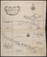
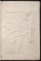
- Creator:
- Dudley, Robert, Sir, 1574-1649
- Published / Created:
- 1647?]
- Call Number:
- 21 1647
- Container / Volume:
- BRBL_00682
- Image Count:
- 1
- Resource Type:
- Maps, Atlases & Globes
- Subject (Geographic):
- Newfoundland and Labrador--Maps--Early
- Subject (Topic):
- Coasts--Newfoundland and Labrador--Maps
- Found in:
- Beinecke Rare Book and Manuscript Library > Carta particolare della Meta Incognita Australe con una parte della America Settentrionale.
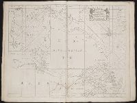
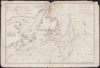
- Creator:
- Cook, James, 1728-1779
- Published / Created:
- 1784
- Call Number:
- 73cea 1784A
- Container / Volume:
- BRBL_00375A
- Image Count:
- 1
- Resource Type:
- Maps, Atlases & Globes
- Subject (Geographic):
- Newfoundland and Labrador--Maps--Early
- Subject (Topic):
- Coasts--Newfoundland and Labrador--Maps
- Found in:
- Beinecke Rare Book and Manuscript Library > Carte reduite de l'île de Terre-Neuve / dressée d'après les plans anglois de James Cook and Michael Lane, et assujettie aux observations astronomiques.
- Creator:
- Cook, James, 1728-1779, creator
Larken, sculpt
- Published / Created:
- 1766. NB. With a book of directions
- Call Number:
- 2003 Folio 85
- Image Count:
- 1
- Subject (Topic):
- -- Maps -- Early works to 1800
- Found in:
- Beinecke Rare Book and Manuscript Library > A chart of part of the south coast of Newfoundland: including the islands St. Peters and Miquelon : from an actual survey taken by order of Commodore Pallisser, Governor of Newfoundland, Labrador, &c
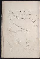
- Creator:
- Gaudy, Iohn
- Call Number:
- 1974 Folio 72
- Collection Title:
- The English pilot: describing the West-India navigation, from Hudson's-Bay to the river Amazones
- Image Count:
- 1
- Subject (Geographic):
- Newfoundland and Labrador --Maps
- Found in:
- Beinecke Rare Book and Manuscript Library > A chart shewing part of the sea coast of New Foundland from ye Bay of Bulls to little Plecentia ...
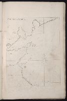
- Call Number:
- 1974 Folio 72
- Collection Title:
- The English pilot: describing the West-India navigation, from Hudson's-Bay to the river Amazones
- Image Count:
- 1
- Subject (Geographic):
- Newfoundland and Labrador --Maps
- Found in:
- Beinecke Rare Book and Manuscript Library > A new and correct chart of the north part of America from New Found Land to Hudsons Bay
- Call Number:
- 1974 Folio 72
- Collection Title:
- The English pilot: describing the West-India navigation, from Hudson's-Bay to the river Amazones
- Image Count:
- 1
- Subject (Geographic):
- Newfoundland and Labrador --Maps
- Found in:
- Beinecke Rare Book and Manuscript Library > Bay Bulls, part of Newfoundland
- Call Number:
- 1974 Folio 72
- Collection Title:
- The English pilot: describing the West-India navigation, from Hudson's-Bay to the river Amazones
- Image Count:
- 1
- Subject (Geographic):
- Newfoundland and Labrador --Maps
- Found in:
- Beinecke Rare Book and Manuscript Library > Cattalina Harbor
- Call Number:
- 1974 Folio 72
- Collection Title:
- The English pilot: describing the West-India navigation, from Hudson's-Bay to the river Amazones
- Image Count:
- 1
- Subject (Geographic):
- Newfoundland and Labrador --Maps
- Found in:
- Beinecke Rare Book and Manuscript Library > Harbor Grace
- Call Number:
- 1974 Folio 72
- Collection Title:
- The English pilot: describing the West-India navigation, from Hudson's-Bay to the river Amazones
- Image Count:
- 1
- Subject (Geographic):
- Newfoundland and Labrador --Maps
- Found in:
- Beinecke Rare Book and Manuscript Library > Port Bonavista
- Creator:
- France. Dépôt des cartes et plans de la marine
- Published / Created:
- 1784
- Call Number:
- 73cea 1784B
- Container / Volume:
- BRBL_00375A
- Image Count:
- 1
- Resource Type:
- Maps, Atlases & Globes
- Subject (Geographic):
- Newfoundland and Labrador--Maps--Early
- Subject (Topic):
- Coasts--Newfoundland and Labrador--Maps
- Found in:
- Beinecke Rare Book and Manuscript Library > Carte réduite des bancs et de L'Ile de Terre-Neuve : avec les côtes du Golfe de St. Laurent et de L'Acadie.