Search
You Searched For
Search Results
- Creator:
- McMullen, H. J
- Published / Created:
- 1928-1930
- Call Number:
- WA MSS S-2611
- Collection Title:
- R. E. Blair collection of Western oil and mining investment prospectuses
- Container / Volume:
- Box 2 | Folder 35
- Image Count:
- 27
- Subject (Topic):
- Petroleum --Texas
- Found in:
- Beinecke Rare Book and Manuscript Library > [Letters: H. J. McMullen to R. E. Blair]
- Creator:
- McMullen, H. J
- Published / Created:
- 1928-1930
- Call Number:
- WA MSS S-2611
- Collection Title:
- R. E. Blair collection of Western oil and mining investment prospectuses
- Container / Volume:
- Box 2 | Folder 36
- Image Count:
- 24
- Subject (Topic):
- Petroleum --Texas
- Found in:
- Beinecke Rare Book and Manuscript Library > [Letters: H. J. McMullen to R. E. Blair]
- Creator:
- McMullen, H. J
- Published / Created:
- 1928-1930
- Call Number:
- WA MSS S-2611
- Collection Title:
- R. E. Blair collection of Western oil and mining investment prospectuses
- Container / Volume:
- Box 2 | Folder 37
- Image Count:
- 37
- Subject (Topic):
- Petroleum --Texas
- Found in:
- Beinecke Rare Book and Manuscript Library > [Letters: H. J. McMullen to R. E. Blair]
- Published / Created:
- 1929
- Call Number:
- WA MSS S-2611
- Collection Title:
- R. E. Blair collection of Western oil and mining investment prospectuses
- Container / Volume:
- Box 3 | Folder 60
- Image Count:
- 14
- Resource Type:
- Archives or Manuscripts
- Subject (Topic):
- Petroleum--Texas
- Found in:
- Beinecke Rare Book and Manuscript Library > Mid-Tex Company
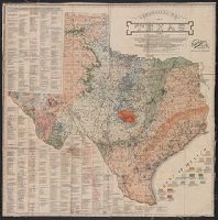
- Creator:
- Standard Blue Print Map and Engineering Company, creator
- Published / Created:
- [1920]
- Call Number:
- 796 1920
- Container / Volume:
- BRBL_00526
- Image Count:
- 1
- Resource Type:
- Maps, Atlases & Globes
- Subject (Topic):
- Petroleum--Texas--Maps
- Found in:
- Beinecke Rare Book and Manuscript Library > Geological map of Texas : showing approximate locations and drilling wells, also names of companies drilling / compiled and for sale by Standard Blue Print Map and Engineering Co.
- Published / Created:
- 1860?]
- Call Number:
- 796gme 1860
- Container / Volume:
- BRBL_00531
- Image Count:
- 1
- Resource Type:
- Maps, Atlases & Globes
- Subject (Topic):
- Petroleum--Texas--Maps
- Found in:
- Beinecke Rare Book and Manuscript Library > A geographically correct map of the Red River, Sabine & Western Railway (under construction) and connections : showing distribution of pine forests (compiled from maps of U.S. government), also location of coal, iron, and oil deposits.