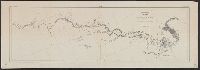
1. Explorations in Alaska 1898 portions of Tanana and White Rivers. Published / Created: 1898 Call Number: 848 T15 1898 Container / Volume: BRBL_00634 Image Count: 1 Resource Type: Maps, Atlases & Globes Subject (Geographic): Tanana River (Alaska)--Maps Found in: Beinecke Rare Book and Manuscript Library > Explorations in Alaska 1898 portions of Tanana and White Rivers.
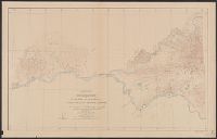
2. Reconnaissance map of Rampart quadrangle, Yukon-Tanana region, Alaska / U.S. Geological Survey Creator: Geological Survey (U.S.) Published / Created: 1909 Call Number: 848 R14 1909 Container / Volume: BRBL_00634 Image Count: 1 Resource Type: Maps, Atlases & Globes Subject (Geographic): Tanana River (Alaska)--Maps Found in: Beinecke Rare Book and Manuscript Library > Reconnaissance map of Rampart quadrangle, Yukon-Tanana region, Alaska / U.S. Geological Survey ; Alfred H. Brooks, geologist in charge.
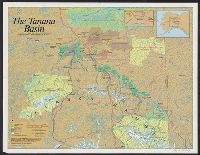
3. The Tanana Basin / cartographics by Steven Fisher. Creator: Fisher, Steven Published / Created: c1989. Call Number: 848 T154 1989 Container / Volume: BRBL_00634 Image Count: 1 Resource Type: Maps, Atlases & Globes Subject (Geographic): Tanana River Watershed (Alaska)--Maps Found in: Beinecke Rare Book and Manuscript Library > The Tanana Basin / cartographics by Steven Fisher.
4. Topographic reconnaissance map of Upper Tanana River Valley region, Alaska / U.S. Geological Survey Creator: Geological Survey (U.S.) Published / Created: 1922 Call Number: 848 T15 1922 Container / Volume: BRBL_00634 Image Count: 1 Resource Type: Maps, Atlases & Globes Subject (Geographic): Tanana River Valley (Alaska)--Maps Found in: Beinecke Rare Book and Manuscript Library > Topographic reconnaissance map of Upper Tanana River Valley region, Alaska / U.S. Geological Survey; Alfred H. Brooks in charge of division; Control and topography by D.C. Witherspoon and J.W. Bagley; Upper Tanana River from boat traverses by W.J. Peters.