Search
You Searched For
Search Results
- Creator:
- Graham, J. D. (James Duncan), 1799-1865
- Published / Created:
- 1836
- Call Number:
- 764 C172 1836
- Container / Volume:
- BRBL_00456A
- Image Count:
- 4
- Resource Type:
- Maps, Atlases & Globes
- Subject (Name):
- United States. Army. Corps of
- Found in:
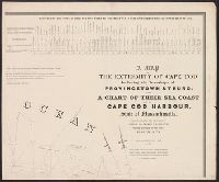
- Beinecke Rare Book and Manuscript Library > A map of the extremity of Cape Cod : including the townships of Provincetown & Truro, with a chart of their sea coast and of Cape Cod Harbour, State of Massachusetts / executed under the direction of Major J.D. Graham ... 1833, '34, & '35.
- Creator:
- Michler, N. (Nathaniel), 1827-1881
- Published / Created:
- 1859?]
- Call Number:
- 89 1866G
- Container / Volume:
- BRBL_00658
- Image Count:
- 1
- Resource Type:
- Maps, Atlases & Globes
- Subject (Name):
- United States. Army. Corps of
- Found in:
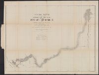
- Beinecke Rare Book and Manuscript Library > General sketch of the survey for an interoceanic ship canal near the Isthmus of Darien via the Rivers Atrato and Truandó / made in accordance with the Act of Congress of March 3rd, 1857, under the direction of the Hon. Secretaries of War and of the Navy
- Creator:
- Abbot, Henry L
- Published / Created:
- 1862?]
- Call Number:
- 783hc 1862H
- Container / Volume:
- BRBL_00511
- Image Count:
- 1
- Resource Type:
- Maps, Atlases & Globes
- Subject (Name):
- United States. Army. Corps of
- Found in:
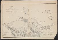
- Beinecke Rare Book and Manuscript Library > Reconnaissance of the battle field at Bull Run, Va., fought July 21, 1861 / made on March 14, 1862 by Henry L. Abbot, 1st Lieut. Top. Engineers.
- Creator:
- McClellan, George Brinton, 1826-1885
- Published / Created:
- 184-?]
- Call Number:
- 884 V47 184X
- Container / Volume:
- BRBL_00654
- Image Count:
- 1
- Resource Type:
- Maps, Atlases & Globes
- Subject (Name):
- United States. Army. Corps of
- Found in:
- Beinecke Rare Book and Manuscript Library > Siege of Vera Cruz : by the U.S. troops under Major General Scott, in March 1847, from surveys made by Major Turnbull, Captains Hughes, McClellan, & Johnston, Lieutenants Derby & Hardcastle, Topl. Engineers ; drawn by Capt. McClellan.
- Creator:
- Simpson, J. H. (James Hervey), 1813-1883
- Published / Created:
- 1850?]
- Call Number:
- 80 1849B
- Container / Volume:
- BRBL_00533
- Image Count:
- 1
- Resource Type:
- Maps, Atlases & Globes
- Subject (Name):
- United States. Army. Corps of
- Found in:
- Beinecke Rare Book and Manuscript Library > Map of route pursued by U.S. troops from Fort Smith, Arkansas, to Santa Fé, New Mexico, via south side of Canadian River in the year 1849 whilst serving as an escort to a party of California emigrants : escort commanded ... by Capt. R.B. Marcy ... Explor
- Creator:
- United States. Army. Corps of Topographical Engineers
- Published / Created:
- 1862
- Call Number:
- 783 1862C
- Container / Volume:
- BRBL_00508
- Image Count:
- 1
- Resource Type:
- Maps, Atlases & Globes
- Found in:
- Beinecke Rare Book and Manuscript Library > Central Virginia / compiled in the Bureau of Topograph'l Eng'rs of the War Department for military purposes July 1862.
- Creator:
- United States. Army. Corps of Topographical Engineers
- Published / Created:
- [1858]
- Call Number:
- 811 Sa22 1858
- Container / Volume:
- BRBL_00553
- Image Count:
- 1
- Resource Type:
- Maps, Atlases & Globes
- Found in:
- Beinecke Rare Book and Manuscript Library > Chart of St. Clair Flats showing the positions of light house & beacon : now in course of erection and the channel excavated in 1857 & 1858 under the direction of Capt. A.W. Whipple, Corps of Topl. Engineers : the new channel was surveyed on the 6th & 7th
- Creator:
- United States. Army. Corps of Topographical Engineers
- Published / Created:
- 1850 [i.e. 1851]
- Call Number:
- 80 1850D
- Container / Volume:
- BRBL_00534
- Image Count:
- 2
- Resource Type:
- Maps, Atlases & Globes
- Found in:
- Beinecke Rare Book and Manuscript Library > Map of the United States and their territories between the Mississippi and the Pacific Ocean, and of part of Mexico / compiled in the Bureau of the Corps of Topogl. Engs. under a resolution of the U.S. Senate, from the best authorities which could be obta
- Creator:
- United States. Army. Corps of Topographical Engineers
- Published / Created:
- 1843
- Call Number:
- 73fab 1843
- Container / Volume:
- BRBL_00375B
- Image Count:
- 1
- Resource Type:
- Maps, Atlases & Globes
- Found in:
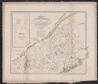
- Beinecke Rare Book and Manuscript Library > Map of the boundary lines between the United States and the adjacent British provinces : from the mouth of the River St. Croix to the intersection of the parallel of 45 degrees of north latitude with the River St. Lawrence near St. Regis.
- Creator:
- United States. Army. Corps of Topographical Engineers
- Published / Created:
- 1843
- Call Number:
- 73fab 1843
- Container / Volume:
- BRBL_00375B
- Image Count:
- 1
- Resource Type:
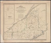
- Maps, Atlases & Globes
- Found in:
- Beinecke Rare Book and Manuscript Library > Map of the boundary lines between the United States and the adjacent British provinces : from the mouth of the River St. Croix to the intersection of the parallel of 45 degrees of north latitude with the River St. Lawrence near St. Regis.