Search
You Searched For
Search Results
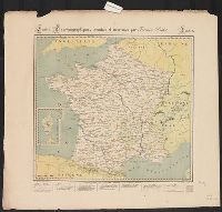
- Creator:
- Didot, Firmin, 1764-1836
- Published / Created:
- [1823?]
- Call Number:
- 38 1823
- Container / Volume:
- BRBL_00154
- Image Count:
- 1
- Resource Type:
- Maps, Atlases & Globes
- Description:
- "The map was printed in eight
- Subject (Geographic):
- France--Maps
- Subject (Topic):
- Map printing
- Found in:
- Beinecke Rare Book and Manuscript Library > Cartes typo-géographiques, inventées et imprimées par Firmin Didot, France [cartographic material] / Jos. Langlois, delin. ; Barbié du Bocage, dir.
- Creator:
- Didot, Firmin, 1764-1836
- Published / Created:
- [1823?]
- Call Number:
- 38 1823
- Container / Volume:
- BRBL_00154
- Image Count:
- 1
- Resource Type:
- Maps, Atlases & Globes
- Subject (Geographic):
- France--Maps
- Subject (Topic):
- Map printing
- Found in:
- Beinecke Rare Book and Manuscript Library > Cartes typo-géographiques, inventées et imprimées par Firmin Didot, France [cartographic material] / Jos. Langlois, delin. ; Barbié du Bocage, dir.
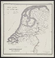
- Creator:
- United States. Office of Strategic Services. Geography Division
- Published / Created:
- 1942
- Call Number:
- 331gmb 1942
- Container / Volume:
- BRBL_00080
- Image Count:
- 1
- Resource Type:
- Maps, Atlases & Globes
- Description:
- "Map no. 601."
- Subject (Topic):
- Road Map--Netherlands
- Found in:
- Beinecke Rare Book and Manuscript Library > Road Systems in the Netherlands / compiled and drawn in Geography Division, O.S.S.
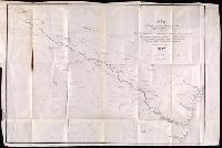
- Creator:
- Eastman, Seth, 1808-1875
Mather, W. W. (William Williams), 1804-1859
Worcester & Norwich Rail-Road Company
- Published / Created:
- 1835
- Call Number:
- Scientific Miscellany 7
- Image Count:
- 2
- Description:
- "A map exhibiting the route surveyed
- Subject (Topic):
- Railroads--Connecticut--Map, 1832
- Found in:
- Beinecke Rare Book and Manuscript Library > Worcester & Norwich Railroad Company, 1835
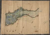
- Creator:
- Mitchell, Donald Grant, 1822-1908, cartographer
- Published / Created:
- Decr. 1863.
- Call Number:
- Roll Map 78
- Image Count:
- 2
- Resource Type:
- cartographic image
- Alternative Title:
- Map of a portion of Westville and New
- Description:
- . Manuscript note on verso (partially trimmed): Map
- Found in:
- Beinecke Rare Book and Manuscript Library > Map of a portion of Westville & New Haven
- Creator:
- Frush, Wm. H. (William H.)
- Published / Created:
- [1850]
- Call Number:
- WA MSS 206
- Collection Title:
- Overland journey across the Plains to Oregon /by William H. Frush, 1850-1852
- Image Count:
- 4
- Abstract:
- Rock, profile of the Snake River, and a map
- Subject (Geographic):
- Oregon --Baker County --Maps
- Found in:
- Beinecke Rare Book and Manuscript Library > [Selected pages]
- Published / Created:
- 1705
- Call Number:
- 1977 +394
- Collection Title:
- Navigantium atque itinerantium bibliotheca: or, A compleat collection of voyages and travels
- Container / Volume:
- Volume 2
- Image Count:
- 1
- Found in:
- Beinecke Rare Book and Manuscript Library > [Map of] Asia
- Published / Created:
- An VIII [1800]
- Call Number:
- 1978 +173
- Collection Title:
- Recueil de cartes géographiques, pour la description de l'Indostan; par le Major J. Rennell
- Image Count:
- 1
- Found in:
- Beinecke Rare Book and Manuscript Library > [Map of] Thibet
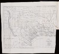
- Call Number:
- Zc52 833hob
- Collection Title:
- Texas
- Image Count:
- 1
- Resource Type:
- Maps, Atlases & Globes
- Found in:
- Beinecke Rare Book and Manuscript Library > Map of the state of Coahuila and Texas
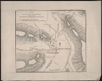
- Published / Created:
- 1890
- Call Number:
- WA MSS S-1404
- Collection Title:
- James W. Forsyth papers, 1865-1932
- Container / Volume:
- Folder 193
- Image Count:
- 1
- Found in:
- Beinecke Rare Book and Manuscript Library > Map No. 3. Scene of the fight with Big Foot's band, December 29. 1890, showing the position of the troops when first shot was fired